
Transport Planning
Transforming Transport Planning Challenges into Strategic Solutions
Fixed Fee Services
We believe in building relationships with our clients which last a lifetime. We’re confident you’ll love what we do.

Transport Assessments
Site Location
Walking Catchment
Cycle Catchment
Public Transport Context
Local Cycling Infrastructure

Healthy Streets Assessments
Active Travel Zone
Neighbourhood Active Travel Zone
Active Travel Routes
Local Cycle Routes

BREEAM
Amentities within 500m
Table of Distances
Bespoke Services
Whatever your GIS needs are for your projects, we’ve got you covered. Our team of analysts and developers are highly skilled in all areas of GIS and data visualisation.
Public Transport Accessibility Analysis
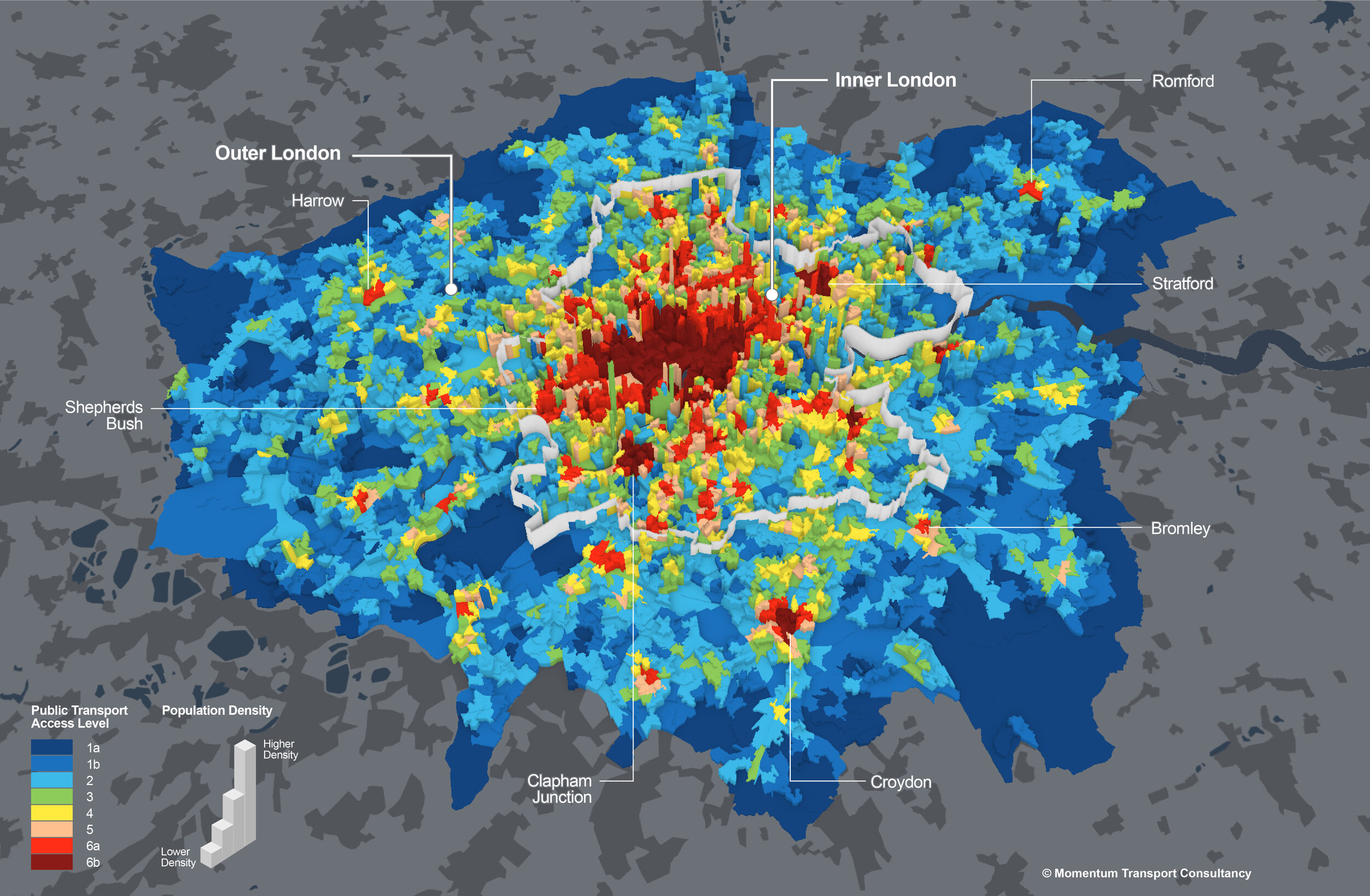
Unlock the full potential of Public Transport Accessibility Levels (PTAL) with our advanced analysis capabilities. Whether you are evaluating existing transportation systems or planning for future scenarios, our expertise in PTAL analysis empowers you to make data-driven decisions that revolutionise urban mobility. Our team of skilled analysts utilises cutting-edge geospatial tools and models to assess accessibility to public transport networks, considering factors such as travel times, frequency, and connectivity. By running comprehensive scenarios, we can simulate the impact of proposed changes, such as new transit routes, station expansions or new masterplan developments allowing you to optimise public transport coverage and improve the overall efficiency of your transportation infrastructure. Our tailored PTAL analyses provide valuable insights for urban planners, policymakers, and transit authorities to enhance the accessibility, reliability, and sustainability of public transportation systems.
15 minute Cities

As cities strive for greater livability and sustainability, understanding the intricate spatial dynamics becomes paramount. Our team of skilled analysts harnesses the power of geospatial data to unravel the intricate tapestry of urban landscapes, unlocking insights that pave the way for 15-minute cities. Through cutting-edge spatial analysis techniques, we assess accessibility, transportation networks, and amenities distribution to optimise urban environments for vibrant, inclusive, and connected communities. Our tailored solutions (Liveable Neighbourhoods) empower city planners, policymakers, and developers to make informed decisions that enhance walkability and promote equitable access to essential services and recreational opportunities.
Pedestrain Movement

Elevate pedestrian experiences and create more pedestrian-friendly environments with our Pedestrian Demand and Flow Analysis services. We specialise in analysing pedestrian movement and demand across study areas, enabling us to provide valuable insights for planning comfortable and efficient pedestrian routes.
Using cutting-edge modeling tools, we accurately assess pedestrian flows, considering factors such as footfall, density, and patterns of movement. By understanding how pedestrians interact with the built environment, we can identify high-demand areas and potential bottlenecks, allowing us to propose targeted improvements to enhance pedestrian comfort and safety..